A HERE CITY site

USDA signs NASA deal to bring satellites and AI into crop reports: What it means for growers
USDA and NASA will work to put satellite data and machine learning into acreage and yield estimates after a NASS corn data error. What it means for growers.
Key takeaways
- USDA and NASA signed an agreement on Oct. 24 to bring satellite data, geospatial analytics and machine learning into USDA’s crop statistics, including acreage and yield estimates.
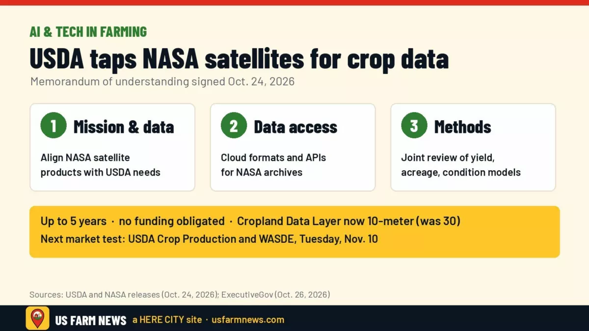
- The agreement runs up to five years and commits no money, ExecutiveGov reported. Any funded project needs a separate agreement.
- It comes just after NASS disclosed a Kansas and Nebraska calculation error in its September corn yield data, which the National Corn Growers Association called “unacceptable,” according to Agri-Pulse.
- Nothing changes in USDA’s report schedule yet. The next big test is the Nov. 10 Crop Production and WASDE.
The numbers that move corn and soybean prices, USDA’s acreage and yield estimates, could eventually lean more on satellites and artificial intelligence. On Oct. 24, USDA Secretary Brooke Rollins and NASA chief Jared Isaacman signed a memorandum of understanding to work together on Earth observation, geospatial analysis and statistical methods for USDA’s agricultural statistics, USDA said. The agreement took effect immediately.
For growers, the practical question is whether this makes USDA’s reports more accurate and timely, and how soon. Here is what the agreement does, what it does not do, and why it lands at a sensitive moment for USDA’s crop numbers.
What the agreement covers
USDA said cooperation may include agricultural statistics, remote sensing, modeling, geospatial data engineering and what the department called “super intelligence/machine learning.” The release listed three working areas:
- Matching missions to needs: regular technical meetings so NASA’s satellite observations and model outputs line up with what USDA’s statisticians require.
- Data access: talks on how USDA can tap NASA archives at scale, including cloud-based formats and APIs.
- Checking the math: joint reviews of the algorithms behind crop condition indicators, yield models, planted and harvested acreage estimates and disaster assessments, including how bias and uncertainty are measured and validated against ground data.
NASA said the goal includes sharper crop monitoring, better acreage and yield numbers, and faster damage assessments after droughts and other disasters. Rollins said in the USDA release that the partnership will “enhance USDA acreage and yield estimation and drive profitability for American agriculture.”
What it does not do
The agreement is a framework, not a funded program. It lasts up to five years and does not require either agency to spend or transfer money, ExecutiveGov reported. Any project involving funds, staff or property would need its own binding agreement. Neither agency announced a date when satellite-based methods would show up in a specific USDA report.
Why now: trust in the numbers
Rollins rolled out a USDA Data Modernization Plan in September, and the NASA deal is part of it. According to ExecutiveGov, the plan responds to falling survey response rates and farmer complaints about reporting burdens. It rests on four pillars: modernizing data reporting, improving acreage and yield estimates, integrating data and technology platforms, and being more transparent with producers. ExecutiveGov also reported that USDA recently sharpened its Cropland Data Layer from 30-meter to 10-meter resolution.
Confidence in USDA’s crop numbers has been shaken this fall. NASS said it had applied the wrong acreage weights to its irrigated and dryland objective yield samples in Kansas and Nebraska, Agri-Pulse reported. The mistake affected September corn population and ear-count data for both states and the 10-state averages, as well as yield forecasts for Kansas, Nebraska and the U.S. NASS said October forecasts were unchanged and that staff will add pre-publication checks.
National Corn Growers Association President Matt Frostic said the error “only further erodes farmer confidence in the agency’s ability to produce statistically sound and accurate reports,” according to Agri-Pulse.
The AI piece: research is moving fast
University researchers are already pushing satellite crop models further. Michigan Farm News described a study from China Agricultural University that used data from 613 counties in 29 U.S. states. The team built a physics-guided deep learning system, called M-Net, that treats differences in satellite viewing angles as information about canopy structure instead of noise. The researchers said the approach could support regional yield forecasts, crop insurance and risk assessment. It is research, not a USDA method.
What it means for your operation
- Keep answering NASS surveys. USDA’s own plan cites falling response rates as a problem, and the agreement calls for validating satellite models against “statistically sound frames and ground data.” Farmer survey responses are a large part of that ground data.
- Watch the Nov. 10 Crop Production report. The market will look closely at USDA’s corn yield, already a sore spot after the September correction. See our week-ahead market outlook for the report calendar.
- Expect better maps before better forecasts. Finer land-use maps such as the 10-meter Cropland Data Layer are the nearest-term benefit. Changes to official yield methods would come later and, under the agreement, after joint review.
- Ask what data you are sharing. As public and private AI tools spread, read the data terms on any platform that uses your field records.
Today’s NASS Crop Progress report comes out at 4 p.m. ET. For more on technology in farming, see our Machinery & Tech section and our report on AI-priced crop insurance.
Get the Daily Ag Business Briefing
Markets, policy and farm business in one free email each weekday.