A HERE CITY site

NOAA Sees 83% Odds of Strong El Niño Through Winter: What a Mild, Wet Pattern Means for Farms and Ranches
NOAA gives a strong El Niño better than 83% odds through March, favoring a mild northern winter and wetter Plains and Southeast. What it means for farms.
Key takeaways
- NOAA’s Climate Prediction Center puts the odds above 83% that El Niño stays in the strong or very strong range through January-March 2027.
- NOAA’s winter outlook leans warmer than normal for the northern tier, upper Mississippi Valley and Great Lakes, and wetter than normal for the Southeast plus the southern and central Plains.
- A drier tilt covers the High Plains, the northern Rockies and pockets of the Great Lakes, a concern for winter moisture.
- Next updates: NOAA’s ENSO discussion on Nov. 12 and new seasonal outlooks on Nov. 19.
The El Niño building in the Pacific could become the strongest in NOAA’s records back to 1950, and forecasters say farmers and ranchers should expect it to steer this winter’s weather. For livestock producers, wheat growers and anyone planning winter fieldwork, that points to a generally milder, and in some regions wetter, season, though not one free of cold snaps.
In its latest monthly ENSO discussion, issued Oct. 8, NOAA’s Climate Prediction Center said El Niño had strengthened further, with sea surface temperatures more than 4 degrees Celsius above normal in parts of the eastern equatorial Pacific. The agency said chances exceed 83% that the event stays strong or very strong through January-March 2027.
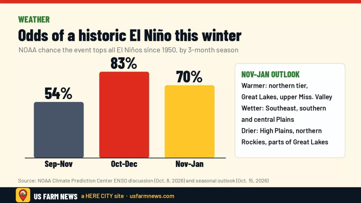
CPC also flagged a high chance of a historic event, one that would top every El Niño back to 1950 by its measure. It put those odds at 83% for the October-December period and 70% for November-January. A stronger event raises the odds of typical El Niño impacts, though CPC said they are not guaranteed.
What NOAA’s winter outlook favors
CPC’s seasonal outlook, issued Oct. 15 and covering November through January, is heavily shaped by the El Niño, forecaster Jon Gottschalck wrote. Highlights for farm country:
- Warmer than normal: the northern tier from the Pacific Northwest across the Midwest and much of the East, the western third of the country and the Ohio Valley, with the highest odds centered on the Great Lakes and upper Mississippi Valley.
- Near-normal temperatures: most of the Southeast.
- Wetter than normal: the Southeast (strongest signal, especially Florida), the southern and central Plains, the lower Mississippi Valley, and large parts of California and the Southwest. CPC said odds of above-normal precipitation top 70% in parts of the far Southeast and northern Florida through January-March.
- Drier than normal: the High Plains, the northern Rockies and some of the Great Lakes region.
CPC expects El Niño of some strength to hang on through March-May 2027, with neutral conditions favored by early summer and potential La Niña conditions in autumn 2027.
What ag meteorologists are telling farmers
Ag meteorologist Matt Makens told Brownfield on Nov. 5 that the shift to El Niño weather is already underway, pointing to recent rain in Texas and Oklahoma and heavy totals in Nebraska, the Dakotas, Minnesota and Iowa. He said the pattern should be “most notable” through November and December and that El Niño cold outbreaks tend to be shorter and less frequent. He still cautioned that sharp swings can stress livestock, and that El Niño patterns can flip mid-winter and bring a colder, wetter start to spring.
Pasture relief may lag. University of Nebraska climatologist Eric Hunt told Brownfield that the heaviest recent rain has mostly fallen on row-crop ground and missed some of the hardest-hit grazing country in Nebraska, Kansas, Colorado and South Dakota. Hunt expects normal to above-normal precipitation ahead and said “a decent winter” could set up better pasture and forage conditions next spring than this year. Brownfield, citing the U.S. Drought Monitor, said half of U.S. hay inventory and 40% of cattle production sit in drought areas.
Pro Farmer said in its Nov. 7 newsletter that welcome Plains rains likely helped the winter wheat crop. Over the next week and a half, Brownfield meteorologist Greg Soulje expects temperatures at or above normal in most areas, while much of the Midwest, the mid-South and the central and northern Plains should run drier than normal.
What it could mean for your operation
- Cattle and dairy: A milder winter can ease feed and bedding needs in the northern Plains and upper Midwest, but plan for short, sharp cold events, as Makens warned.
- Poultry and dairy biosecurity: Nancy Barr of the Michigan Allied Poultry Industry told Brownfield producers worry an El Niño winter could prolong bird flu risk. See our report on state officials’ push for a dairy HPAI vaccine.
- Winter wheat: Wetter odds in the central and southern Plains are encouraging for moisture; drier odds in the High Plains and northern Rockies are not.
- Southeast fieldwork: The strongest wet signal in the Southeast could complicate winter field access and harvest of late crops.
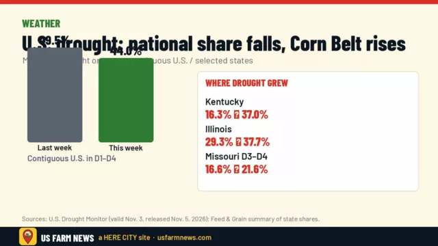
- Drought watch: Compare the outlook with current conditions in our latest Drought Monitor report.
What to watch
CPC’s next ENSO diagnostic discussion is scheduled for Nov. 12, and its next set of seasonal outlooks is due Nov. 19. Both will show whether the forecast is holding as El Niño nears its expected peak this winter.
Frequently asked questions
Does El Niño mean a warm winter in the Midwest?
NOAA’s November-January outlook favors above-normal temperatures across the northern tier, including the upper Mississippi Valley and Great Lakes, but short cold outbreaks are still possible, ag meteorologist Matt Makens told Brownfield.
Which farm regions look wetter this winter?
NOAA’s outlook tilts wetter for the Southeast, the southern and central Plains, the lower Mississippi Valley, and much of California and the Southwest.
When is the next NOAA update?
The ENSO discussion is due Nov. 12, 2026, and new seasonal outlooks are due Nov. 19, 2026.
Get the Daily Ag Business Briefing
Markets, policy and farm business in one free email each weekday.